
Scotland's Draft Peatland Condition Tool: What It Rewards and What It Penalises
- Rob Beeson

- Jun 8
- 3 min read
✅ Key Takeaway: NatureScot recommends judging peatland by hydrological function and landscape connectivity rather than fixed depth thresholds, and offers a draft field tool for scoring condition.
Scotland is building a new system to decide how much damage a development does to peat, and how much restoration should pay for it.
A report commissioned by NatureScot warns that the system rests on words too vague to apply consistently, starting with what an "active" or "functioning" peatland even means. Without clearer definitions, the authors argue, decisions become easier to challenge and more open to subjective interpretation.
The report does two jobs. It sets out how the key terms should be read, and it builds a field tool for scoring peatland condition that is meant to feed the forthcoming Scottish Planning Biodiversity Metric, the calculation that fixes how much biodiversity a development must protect or replace.
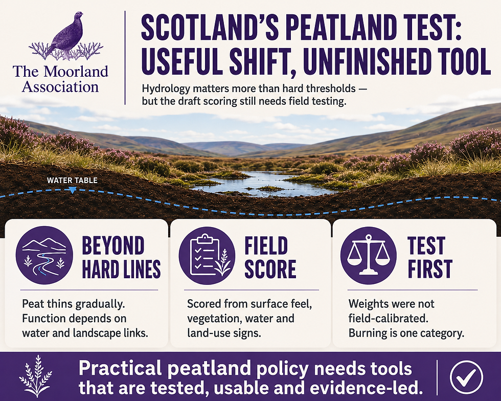
Its main recommendation is a shift away from rigid thresholds based on peat depth or area, towards judging whether a peatland still works as a connected hydrological system.
Moving beyond hard thresholds
Scottish policy has long leaned on fixed cut-offs, such as the 50 cm depth and 60% organic-matter figures used to separate peat from other soils. The report argues these create artificial "hard edges" where one policy stops and another starts, even though peat thins gradually on the ground and is governed by processes that run across whole catchments.
It then makes a point familiar to anyone who works upland ground. Peatlands cycle between growth and erosion, so across a landscape a working bog always holds some areas gaining peat ("active") and some losing it ("inactive"). Drier margins are needed for wetter centres to exist, which means expecting an entire site to be uniformly "active" is unrealistic.
The report also recommends that ground where peat has already been lost should still be assessed, because much of it can form peat again under the right management. Its list of causes of that loss includes peat extraction, erosion, drainage, overgrazing and burning, though it does not separate managed muirburn from wildfire or severe burns within that list.
A field tool built on "bog breathing"
To score condition on the ground, the authors adapted a peer-reviewed method, the InSAR Rapid Assessment Tool (Bradley et al., 2025). It was built to validate satellite readings of "bog breathing", the slow rise and fall of the peat surface as it gains and loses water, and the published version could be completed by untrained surveyors in under five minutes after brief training.
The adapted tool scores four things: how the surface feels underfoot, vegetation, hydrology, and current and historical land use. Each feature carries a positive or negative weight set by expert judgement. Bog-mosses (Sphagnum) score highest, followed by pools, surface micro-topography and a spongy near-natural surface.
The heaviest penalties fall on commercial forestry, self-seeded non-native conifers and bare peat. Burning, grazing, peat cutting and access tracks each carry the lightest penalty, a single point, and the tool applies one undifferentiated "burning" weight whether the cause is managed cool burning or a destructive wildfire.
Scores are summed into five condition classes, from near-natural bog down to actively eroding peat or conifer plantation.
The weights were not field-calibrated against measured emissions or recovery outcomes; they were tuned iteratively against 29 synthetic scores covering 27 peatland scenarios plus two boundary cases, built from past survey data and expert knowledge.
The authors are explicit that this is a draft and should be scrutinised and tested against real survey data before use.
What it means for managing peat
The practical stakes for estates sit in that scoring. A condition score feeds straight into how much restoration or offsetting a development must fund, so the weight attached to each land use is not academic for anyone weighing a renewable energy scheme, new tracks or similar works on peat.
A tool that penalises all burning equally, on expert judgement rather than measured outcomes, is the kind of detail an evidence-led reader will want tested before it sets compensation bills.
On the science, the report is on firmer ground. It treats water-table depth as a key control on whether peat stores or releases carbon, alongside temperature and the make-up of the peat itself, and points to a narrow band identified by Evans et al. (2021), roughly 5 to 13 cm below the surface, where long-term carbon gains outweigh methane losses.
The field measures it asks for follow from this: vegetation and water-table depth, rather than costly direct carbon monitoring.
This is a Scottish report for Scottish planning, and its machinery does not transfer to England or Wales. But the underlying science applies across British uplands, and a scoring system that penalises managed burning without field evidence is one the Moorland Association will want grounded before any version of it is adopted south of the border.

